The park is bordered on the north by Waterton Lakes National Park in Alberta, and the Flathead Provincial Forest and Akamina-Kishinena Provincial Park in British Columbia. To the west, the north fork of the Flathead River forms the western boundary, while its middle fork is part of the southern boundary. The Blackfeet Indian Reservation provides most of the eastern boundary, and the Lewis and Clark and the Flathead National Forests form the southern and western boundary. The remote Bob Marshall Wilderness Complex is located in the two forests immediately to the south.
The park contains a dozen large lakes and 700 smaller ones, but only 131 lakes have been named.[31] Lake McDonald on the western side of the park is the longest at 9.4 miles (15.1 km), the largest in area at 6,823 acres (27.61 km2) and the deepest at 464 feet (141 m). Numerous smaller lakes, known as tarns, are located in cirques formed by glacial erosion. Some of these lakes, like Avalanche Lake and Cracker Lake, are colored an opaque turquoise by suspended glacial silt, which also causes a number of streams to run milky white. The lakes of Glacier National Park remain cold year round, with temperatures rarely above 50 °F (10 °C) at their surface. Cold water lakes such as these support little plankton growth, ensuring that the lake waters are remarkably clear. The lack of plankton, however, lowers the rate of pollution filtration, and pollutants have a tendency to linger longer. Consequently, the lakes are considered environmental bellwethers as they can be quickly affected by even minor increases in pollutants.
 |
| Two Medicine Lake with Sinopah Mountain |
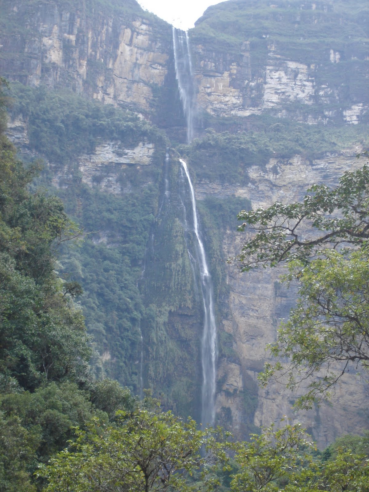
Two hundred waterfalls are scattered throughout the park, however, during drier times of the year, many of these are reduced to a trickle. The largest falls include those in the Two Medicine region, McDonald Falls in the McDonald Valley and Swiftcurrent Falls in the Many Glacier area, which is easily observable and close to the Many Glacier Hotel. One of the tallest waterfalls is Bird Woman Falls, which drops 492 feet (150 m) from a hanging valley beneath the north slope of Mount Oberlin.
Geology
The rocks found in the park are primarily sedimentary rocks of the Belt Supergroup. They were deposited in shallow seas over 1.6 billion to 800 million years ago. During the formation of the Rocky Mountains 170 million years ago one region of rocks now known as the Lewis Overthrust was forced eastward 50 miles (80 km). This overthrust was several miles (kilometers) thick and hundreds of miles (kilometers) long. This resulted in older rocks being displaced over newer ones, so the overlying Proterozoic rocks are between 1.4 and 1.5 billion years older than Cretaceous age rocks they now rest on.
 |
| Grinnell Galcier 1938 |
One of the most dramatic evidences of this overthrust is visible in the form of Chief Mountain, an isolated peak on the edge of the eastern boundary of the park rising 2,500 feet (800 m) above the Great Plains. There are six mountains in the park over 10,000 feet (3,000 m) in elevation, with Mount Cleveland at 10,466 feet (3,190 m) being the tallest. Appropriately named Triple Divide Peak sends waters towards the Pacific Ocean, Hudson Bay, and Gulf of Mexico watersheds, and can effectively be considered to be the apex of the North American continent, although the mountain is only 8,020 feet (2,444 m) above sea level.
Stromatolites found in the Siyeh Formation which has been dated to be more than one billion years old
The rocks in Glacier National Park are the best preserved Proterozoic sedimentary rocks in the world, and have proved to be some of the world's most fruitful sources for records of early life. Sedimentary rocks of similar age located in other regions have been greatly altered by mountain building and other metamorphic changes, and consequently fossils are less common and more difficult to observe. The rocks in the park preserve such features as millimeter-scale lamination, ripple marks, mud cracks, salt-crystal casts, raindrop impressions, oolites and other sedimentary bedding characteristics. Six fossilized species of Stromatolites, which were early organisms consisting primarily blue-green algae, have been documented and dated at about 1 billion years. The discovery of the Appekunny Formation, a well preserved rock stratum in the park, pushed back the established date for the origination of animal life a full billion years. This rock formation has bedding structures which are believed to be the remains of the earliest identified metazoan (animal) life on Earth.
 |
| Grinnell Galcier 1981 |
Glaciers
Glacier National Park is dominated by mountains which were carved into their present shapes by the huge glaciers of the last ice age; these glaciers have largely disappeared over the last 12,000 years. Evidence of widespread glacial action is found throughout the park in the form of U-shaped valleys, glacial cirques, arêtes and large outflow lakes radiating like fingers from the base of the highest peaks. Since the end of the ice ages, various warming and cooling trends have occurred. The last recent cooling trend was during the Little Ice Age which took place approximately between 1550 and 1850. During the Little Ice Age, the glaciers in the park expanded and advanced, although to nowhere near as great an extent as they had during the Ice Age.
During the middle of the 20th century, examination of the maps and photographs from the previous century provided clear evidence that the 150 glaciers known to have existed in the park a hundred years earlier had greatly retreated, and in many cases disappeared altogether. Repeat photography of the glaciers, such as the pictures taken of Grinnell Glacier between 1938 and 2009 as shown, help to provide visual confirmation of the extent of glacier retreat.
 |
| Grinnell Galcier 1998 |
In the 1980s, the U.S. Geological Survey began a more systematic study of the remaining glaciers, which continues to the present day. By 2010, 37 glaciers remained, but only 25 of these were considered to be "active glaciers" of at least 25 acres (0.10 km2) in area. Scientists generally agree that if the current climate conditions continue, most of the remaining glaciers in the park will be gone by 2030 or even as soon as 2020. This glacier retreat follows a worldwide pattern that has accelerated even more since 1980. Without a major climatic change in which cooler and moister weather returns and persists, the mass balance, which is the accumulation rate versus the ablation (melting) rate of glaciers, will continue to be negative and the glaciers will eventually disappear, leaving behind only barren rock.
After the end of the Little Ice Age in 1850, the glaciers in the park retreated moderately until the 1910s. Between 1917 and 1941, the retreat rate accelerated and was as high as 330 feet (100 m) a year for some glaciers. A slight cooling trend from the 1940s until 1979, helped to slow the rate of retreat and in a few examples some glaciers even advanced a few tens of meters. However, during the 1980s, the glaciers in the park began a steady period of loss of glacial ice, which continues as of 2010. In 1850, the glaciers in the region near Blackfoot and Jackson Glaciers covered 5,337 acres (21.6 km2), but by 1979, the same region of the park had glacier ice covering only 1,828 acres (7.4 km2). Between 1850 and 1979, 73% of the glacial ice had melted away. At the time the park was created, Jackson Glacier was part of Blackfoot Glacier, but the two have separated into two glaciers since.
The impact of glacier retreat on the park's ecosystems is not fully known, but cold water dependent plant and animal species could suffer due to a loss of habitat. Reduced seasonal melting of glacial ice may also affect stream flow during the dry summer and fall seasons, reducing water table levels and increasing the risk of forest fires. The loss of glaciers will also reduce the aesthetic visual appeal that glaciers provide to visitors.
 |
| Grinnell Galcier 2009 |
Climate
As the park spans the Continental Divide, and has more than 7,000 feet (2,100 m) in elevation variance, many climates and microclimates are found in the park. As with other alpine systems, average temperature usually drop as elevation increases. The western side of the park, in the Pacific watershed, has a milder and wetter climate. Precipitation is greatest during the winter and spring averaging 2 to 3 inches (50 to 80 mm) per month. Snowfall can occur at any time of the year, even in the summer, and especially at higher altitudes. The winter can bring prolonged cold waves, especially on the eastern side of the Continental Divide. Snowfalls are significant over the course of the winter, with the largest accumulation occurring in the west. During the tourist season daytime high temperatures average 60 to 70 °F (15 to 20 °C), and nighttime lows usually drop into the 40 °F (5 °C) range. Temperatures in the high country may be much cooler. In the lower western valleys, daytime highs in the summer may reach 90 °F (30 °C).
Going-to-the-Sun Road in summer
Rapid temperature changes have been noted in the region, and in Browning, Montana, which is just east of the park in the Blackfeet Reservation, a world record temperature drop of 100 °F (56 °C) in only 24 hours occurred on the night of January 23–24, 1916, when thermometers plunged from 44 to -56 °F (7 to -49 °C).
 |
| The Big Drift covering the Going-to-the-Sun Road |
Glacier National Park has a highly regarded global climate change research program. Based in West Glacier, with its main headquarters in Bozeman, Montana, the U.S. Geological Survey has performed scientific research on specific climate change studies since 1992. In addition to the study of the retreating glaciers, research performed includes forest modeling studies in which fire ecology and habitat alterations are analyzed. Additionally, changes in alpine vegetation patterns are documented, watershed studies in which stream flow rates and temperatures are recorded frequently at fixed gauging stations, and atmospheric research in which UV-B radiation, ozone and other atmospheric gases are analyzed over time. The research compiled contributes to a broader understanding of climate changes in the park. The data collected, when compared to other facilities scattered around the world, help to correlate these climatic changes on a global scale.
Glacier is considered to have excellent air and water quality. No major areas of dense human population exist anywhere near the region and industrial effects are minimized due to a scarcity of factories and other potential contributors of pollutants. However, the sterile and cold lakes found throughout the park are easily contaminated by airborne pollutants that fall whenever it rains or snows, and some evidence of these pollutants has been found in park waters. The pollution level is currently viewed as negligible, and the park lakes and waterways have a water quality rating of A-1, the highest rating given by the state of Montana.
 |
| Going-to-the-Sun Road in summer |