Tuesday, November 29, 2011

Pedra Azul

Pedra Azul (Portuguese for "blue stone") is a Brazilian city in the state of Minas Gerais, located in the northeast of the state, in the Jequitinhonha River valley region. The population in 2007 was 24,851 in a total area of 1,619 km².

The city belongs to the mesoregion of Jequitinhonha and to the microregion of Pedra Azul. The elevation of the municipal seat is 617 meters. It became a municipality in 1911. This municipality is located 16 km. to the east of the important BR-116 highway, which links Rio de Janeiro to Salvador. The boundary with the state of Bahia is 49 km. to the northeast.

Pedra Azul is also a statistical microregion that includes the following municipalities: Cachoeira de Pajeú, Comercinho, Itaobim, Medina, and Pedra Azul.

The main economic activities are cattle raising and farming. The GDP was R$111,200,000 (2005). There were 2 banking agencies in 2006. In the rural area there were 570 farms with around 1,700 people involved in the agricultural sector. There were 58 tractors, a ratio of one tractor for every 10 farms. The main crops were bananas, coffee, passion fruit, beans, manioc, and corn. In the health sector there were 10 health clinics and 1 hospital with 66 beds. The score on the Municipal Human Development Index was 0.660. This ranked Pedra Azul 709 out of 853 municipalities in the state, with Poços de Caldas in first place with 0.841 and Setubinha in last place with 0.568. See Frigoletto for the complete list.

Friday, November 11, 2011

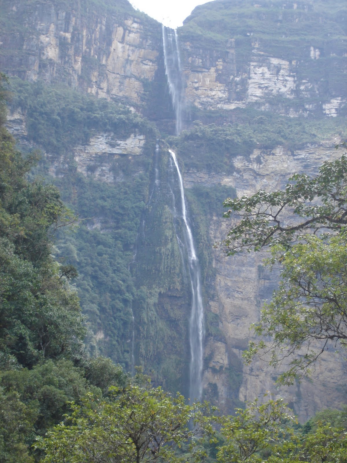
Gocta Cataracts a perennial waterfall with two drops

Gocta is a perennial waterfall with two drops located in Peru's province of Chachapoyas in Amazonas, approximately 700 kilometres (430 mi) to the northeast of Lima. It flows into the Cocahuayco River. Although the waterfall had been well known to locals for centuries (it is in full view of a nearby village), its existence was not made known to the world until after an expedition made in 2005 by a German, Stefan Ziemendorff, with a group of Peruvian explorers.

At the time of the discovery Ziemendorff successfully persuaded the Peruvian government to map the falls and to measure their height. On 11 March 2006, following his third expedition to the falls, he held a press conference, the contents of which were published by several of the world's wire services. He stated that the total height was measured at 771 metres (2,530 ft), which ranked Gocta as the third tallest free-leaping waterfall in the world after Angel Falls in Venezuela and Tugela Falls in South Africa. However, this was apparently based on outdated and incomplete information gleaned from the National Geographic Society, and Ziemendorff's comments as to the waterfalls' ranking have since been widely disputed. Citing various encyclopedias, reference books, and webpages accessible through Google, Gocta Cataracts are unofficially listed as the world's fifth-tallest, after adding Ramnefjellsfossen (Norway) and Mongefossen (Norway). Furthermore, The World Waterfall Database ranks Gocta as the 16th tallest.

The waterfall, which can be seen from kilometers away, has been christened Gocta Falls, after the name of the nearest settlement.

The daily El Comercio said that the impressive waterfall had remained unknown to outsiders until now, because local people feared the curse of a beautiful blond mermaid who lived in its waters, if they revealed its whereabouts. "The falls are supposed to be protected by a white haired mermaid like spirit whos hair can be seen flowing down the massive U shaped walls at the bottom of the falls."


On 13 March 2006, the Peruvian government announced to the press that the area surrounding the falls would be developed as a tourist attraction, with a target date for sometime in mid-2007. A small hotel was built 6-miles from the base of the waterfall, with all rooms having views of the waterfall. Tourists can now hike the trails by foot or horse to the misty base of the waterfall. The nearby town of Chachapoyas is located at an altitude of 2235 meters (7657 ft). The waterfall is at a slightly higher altitude and thus clouds can be seen to occasionally eclipse part of the view.


Monday, October 31, 2011

Auyantepui location of Angel Falls

Auyantepui (Auyantepuy, Auyan-Tepui or Aiyan-Tepui), which in the language of the native Pemon people means "Devil's Mountain". It is visited on average three times a year. Despite this, it is one of the most famous tepuis (table-top mountains) in Venezuela. It is one of the largest (but not the highest) tepuis with an area of 700 km2 (270 sq mi) in the Guayana Highlands and is located in the Gran Sabana region in Bolivar State.

Angel Falls, the highest waterfall in the world, drops from a cleft near the summit. The falls are 979 meters (3,212 ft) high, with an uninterrupted descent of 807 meters (2,648 ft). Angel Falls is more than 19 times higher than Niagara Falls.


Auyantepui achieved international fame in 1933 when Angel Falls was accidentally discovered by Jimmie Angel, a bush pilot who was on a trip in search of gold ore. During a return trip in 1937, Angel crashed his small plane Flamingo on top of the heart-shaped table mountain. It took him and his crew 11 days to walk down off the mountain. He was immortalized when the waterfall was named after him.

Auyantepui is a giant among the large plateaus. It encompasses 650 km2 (250 sq mi) and its peak is 2,535 meters (8,317 ft) high.

Tuesday, October 25, 2011

Royal Gorge Cliff

The Royal Gorge (also Grand Canyon of the Arkansas) is a canyon on the Arkansas River near Cañon City, Colorado. With a width of 50 feet (15 m) at its base and a few hundred feet at its top, and a depth of 1,250 feet (380 m) in places, the 10-mile-long canyon is a narrow, steep gorge through the granite of Fremont Peak. It is one of the deepest canyons in Colorado.

Natural history

The path of the Arkansas River was already set when the granite uplift that would eventually form the Rocky Mountains began. About 3 million years ago as the mountains began to rise from the surrounding plains, the Arkansas River--then only a small rivulet--began to wear away at the stone it flowed across. Scientists estimate that the mountains surrounding the canyon rose at a rate of approximately one foot every 2500 years. Over the millennia, this small stream grew, cutting a deep channel for itself through the surrounding granite. The gorge's peculiar shape, contrasted to broad canyons such as the Grand Canyon, can be attributed to this long, direct erosion through hard rock.


Early history and European settlement

Before European settlement, Native Americans of the Ute people wintered in Royal Gorge for its protection from wind and relatively mild climate. The Comanche, Kiowa, Sioux, and Cheyenne used Royal Gorge on buffalo hunting expeditions as an access point to mountain meadow regions such as South Park Basin. Colorado's Rocky Mountain region fell under Spanish claims, and conquistador expeditions of the 17th century or fur traders may have seen Royal Gorge in their traversal of the area. The first recorded instance of a European arrival, however, is the Pike expedition of 1806. Zebulon Pike's group built a crude shelter in the gorge and explored the area, descending on horseback over the frozen Arkansas River.

Nearby Cañon City was founded in 1860 to exploit possible mineral deposits in the area. Discovery of silver and lead near Leadville in 1877 prompted a race to build rail access to the area. Royal Gorge was a bottleneck along the Arkansas too narrow for both the Atchison, Topeka and Santa Fe Railway and the Denver and Rio Grande Western Railroad to pass through, and there was no other reasonable access to the South Park area. Both railroad crews thus took to fighting the "Royal Gorge Railroad War", two years of essentially low-level guerrilla warfare between the two companies. Federal intervention prompted the so-called "Treaty of Boston" to end the fighting. The D&RGW completed its line and leased it for use by the Santa Fe.

In the 1890s Royal Gorge was used as a passenger route for transcontinental rail travel. As many as four trains per day went through the gorge, though in time the establishment of alternate routes through the mountains made the Royal Gorge fall from favor for transcontinental use, and passenger train service on the main line was discontinued in 1967. A sightseeing train now follows the route through the gorge.


Modern history

On May 7, 1879 the first excursion train traveled through the Royal Gorge after years of court battles between the Denver & Rio Grande and the Atchison, Topeka & Santa Fe (AT&SF or Santa Fe) railroads.

The Royal Gorge Route Railroad now operates excursion trains through the Royal Gorge throughout the year. The train travels 12-miles through the canyon from Cañon City, Colorado to Parkdale and return.

In 1929 Cañon City authorized the building of the Royal Gorge Bridge, which at 955 feet (291 m) above the river held the record of highest bridge in the world from 1929 to 2003. The bridge forms the kernel of Royal Gorge Park, a theme park owned and run by the city.

In the summer months, whitewater rafting is a very popular activity in the Royal Gorge. Tourists travel from around the world to tackle the Class IV rapids of the Arkansas River and enjoy the scenery of the gorge.
A view of the Royal Gorge Bridge, from below

Named rapids in the Royal Gorge include Sunshine Falls, Sledgehammer, Wallslammer, Corkscrew, the Narrows, Boateater and Soda Pop Rock. River recreation in the royal gorge is regulated by Arkansas Headwaters Recreation Area (AHRA) and daily user fees are required to launch at all of the recreation sites upstream of the Royal Gorge. There are many commercial rafting companies which are licensed by AHRA to run the Royal Gorge and summer weekends can see hundreds of rafts packing the river.

Base jumping, bungee jumping, and rock climbing are generally not permitted at the Royal Gorge; however, during special events such as the "Go Fast Games" these sports have been temporarily allowed. However, it is only allowed with the consent of the land owners.

Monday, October 24, 2011

Longs Peak Diamond, Rocky Mountain National Park, Colorado

Longs Peak is one of the 53 mountains with summits over 14,000 feet in Colorado. It can be prominently seen from Longmont, Colorado, as well as from the rest of the Colorado Front Range. It is named after Major Stephen Long, who explored the area in the 1820s. Longs Peak is one of the most prominent mountains in Colorado, rising 7,000 feet above the town of Estes Park, Colorado to the northeast.

Together with the nearby Mount Meeker, the two are sometimes referred to as the Twin Peaks (not to be confused with a nearby lower mountain called Twin Sisters).

History of ascents

As the only "fourteener" in Rocky Mountain National Park, the peak has long been of interest to climbers. The easiest route is not "technical" during the summer season. It was probably first used by pre-Columbian indigenous people collecting eagle feathers.

The first recorded ascent was in 1868 by the surveying party of John Wesley Powell. The East Face of the mountain is quite steep, and is surmounted by a gigantic sheer cliff known as "The Diamond" (so-named because of its shape, approximately that of a cut diamond seen from the side and inverted - see image at right). Another famous profile belongs to Longs Peak: to the southeast of the summit is a series of rises which, when viewed from the northeast, resembles a beaver. The photo shows the beaver climbing the south (left side) of the mountain.

In 1954 the first proposal made to the National Park Service to climb The Diamond was met with an official closure, a stance not changed until 1960. The Diamond was first ascended by Dave Rearick and Bob Kamps that year, by a route that would come to be known simply as D1. This route would later be listed in Allen Steck and Steve Roper's influential book Fifty Classic Climbs of North America. The easiest route on the face is the Casual Route, first climbed in 1977. It has since become the most popular route up the wall.


Mills Glacier

Longs Peak has one glacier named Mills Glacier. The glacier is located around 12,800 feet (3,900 m) at the base of the Eastern Face, just above Chasm Lake. Another permanent snowfield, called The Dove, is located north of Longs Peak. Longs Peak is one of fewer than 50 mountains in Colorado that have a glacier.

Hiking Longs Peak

Trails that ascend Longs Peak include the East Longs Peak Trail, the Longs Peak Trail, the Keyhole Route, Clark's Arrow and the Shelf Trail. Most days, no technical climbing is required to reach the summit of Longs Peak during the summer season, which typically runs from mid July through early September. Outside of this window the popular "Keyhole" route is still open, however its rating is upgraded to "technical" as treacherous ice formation and snow fall necessitates the use of specialized climbing equipment including, at a minimum, crampons and an ice axe. It is one of the most difficult Class 3 fourteener scrambles in Colorado.

The hike from the trailhead to the summit is 8 miles (13 km) each way. Most hikers begin before dawn in order to reach the summit and return below the tree line before frequent afternoon thunderstorms bring a risk of lightning strikes. The most difficult portion of the hike begins at the Boulder Field, 6.4 miles (10 km) into the hike. After scrambling over the boulders, hikers reach the Keyhole at 6.7 miles (10.5 km).


The following quarter of a mile involves a scramble along narrow ledges, many of which may have nearly sheer cliffs of 1,000 feet (305 m) or more just off the edge. The next portion of the hike includes climbing over 600 vertical feet (183 m) up the Trough before reaching the most exposed section of the hike, the Narrows. Just beyond the Narrows, the Notch signifies the beginning of the Homestretch, a steep climb to the football field-sized, flat summit. It is possible to camp out overnight in the Boulder Field (permit required) which makes for a less arduous two day hike, although this is fairly exposed to the elements. 57 people have died climbing or hiking Longs Peak. According to the National Park Service, 2 people, on average, die every year attempting to climb the mountain. In the summer of 2005 a Japanese climber was blown off a ledge after reaching the summit. On September 3, 2006 a man fell 800 feet (244 m) to his death when some rocks let go while he was descending the Loft route. Less experienced mountaineers are encouraged to use a guide for this summit to mitigate risk and increase the probability of a summit.

For hikers who do not wish to climb to the summit, there are less-involved hikes on the peak as well. Peacock Pool and Chasm Lake are popular hiking destinations and follow well-maintained trails. It is also rewarding to hike just to the Boulder Field, the Keyhole, or the seldom-visited but spectacular Chasm View. Camping is available at the Boulder Field and also on the lower portions of the mountain, such as Goblin's Forest next to the stream at the bottom. Technical climbers, with the correct permit, are allowed to use "bivy" sites at the base of the East Face and at Chasm View. It is also possible to camp to the south of the mountain at Sand Beach Lake.


Climbing Longs Peak

In addition to the standard "Keyhole" route, there are more serious and more technical climbs on Longs Peak. Climbers should seek qualified instruction; deaths on Longs Peak are an annual occurrence. Some of the more common routes are, in approximate order of popularity,
  • North Face Cables route. This follows the Keyhole route to the Boulder Field, then ascends the North Face of the peak. It requires one or two pitches of low-5th class climbing, and is often downclimbed or rappelled by technical climbers since it is one of the fastest ways to ascend or descend the peak. In the early 20th century, enterprising guides installed a series of large steel eye bolts along this route, connecting them with a steel cable similar to systems in the Alps. The cables were removed in 1973 due to the lightning hazard, but the bolts remain and are used as rappel anchors.
  • Kieners Route. A traditional mountaineering climb that involves a climb of Lambs Slide, which is icy later in the season, then an exposed traverse of the Broadway ledge, and then low-5th class climbing. Lambs Slide is so-named because of the Reverend Elkanah J. Lamb's nearly fatal tumble down it . The most recent fatal tumble was November, 2006.
  • via the Loft. The Loft is the semi-permanent snowfield between Longs Peak and its south-eastern neighbor Mt. Meeker. From the saddle you can traverse to either peak. One such traverse route is Gorilla's Traverse. It is also possible to ascend to the saddle via Lambs Slide.
  • via the East Face. The East Face is the steep, 1,000 + foot (305 + m) wall that includes the Diamond and the Lower East Face. All climbs here are technical, from 5.10 to 5.13. It is also possible to ascend to the (climber's) left of the Diamond face proper. The routes on the right side of the Diamond are often aid climbed, and may require spending the night on the wall; the rock here can be very wet. Routes on the left side of the Diamond are usually free climbed. Only qualified climbers should attempt climbs on this face, and should take into consideration the effects of altitude and alpine conditions in addition to the difficulty rating.
  • via the Notch Couloir. This is a technical climb involving rock climbing and, at some times of year, ice climbing. The Notch Couloir is to the (climber's) left of the Diamond face.

Thursday, October 20, 2011

Recreation of Galcier National Park

Glacier is distant from major cities, and the closest airport is at Kalispell, Montana, southwest of the park. Amtrak trains stop at East and West Glacier. A fleet of restored 1930s White Motor Company coaches, called Red jammers, offer tours on all the main roads in the park. The drivers of the buses are called "Jammers," due to the gear-jamming that formerly occurred during the vehicles' operation. The tour buses were rebuilt in 2001. The buses were rebuilt by Ford Motor Company. The bodies were removed from their original chassis and built on modern Ford E-Series van chassis. They were also converted to run on propane, to lessen their environmental impact.

A number of historic wooden tour boats, some dating back to the 1920s, operate on several of the larger lakes. Several of these boats have been in continuous seasonal operation on the major lakes of Glacier National Park since 1927 and carry up to 80 tourists.


Hiking is a popular activity in the park. Over half of the visitors to the park report taking a hike on the park's nearly 700 miles (1,127 km) of trails. 110 miles (177 km) of the Continental Divide National Scenic Trail spans most of the distance of the park north to south, with a few alternative routes at lower elevations if high altitude passes are closed due to snow. The Pacific Northwest National Scenic Trail crosses the park on 52 miles (84 km) from east to west.

Due to the presence of bears and other large mammals, dogs are not permitted on any trails in the park, though they are permitted at front country campsites that can be accessed by a vehicle, and along paved roads. Anyone entering the United States over land or waterway from Canada must have an appropriate passport with them.


Numerous day hiking options are available throughout the park. Backcountry camping is allowed at campsites along the trails. A permit is required, which can be obtained from certain visitor centers or arranged for in advance. Much of Glacier's backcountry is usually inaccessible to hikers until early June due to accumulated snowpack and potential avalanche risk, and many trails at higher altitudes remain snow packed until July. The major campgrounds that allow vehicle access are found throughout the park, most of which are near one of the larger lakes. The campgrounds at St. Mary and at Apgar are open year round, but conditions are considered primitive in the off-season, as the restroom facilities are closed and there is no running water. All campgrounds with vehicle access are usually open from mid-June until mid-September. Guide and shuttle services are also available.

Fishing is a popular activity in the park and some of the finest fly fishing in North America can be found in the streams that flow through the park. Though the park requires that those fishing understand the regulations, no permit is required to fish the waters within the park boundary. The endangered bull trout must be released immediately back to the water if caught, otherwise, the regulations on limits of catch per day are liberal.

Winter recreation activities in Glacier are limited. Snowmobiling is illegal throughout the park, but cross-country skiing is permitted in the lower altitude valleys away from potential avalanche zones.

Wildlife and ecology of Glacier National Park

Flora

Glacier is part of a large preserved ecosystem collectively known as the "Crown of the Continent Ecosystem", all of which is primarily untouched wilderness of a pristine quality. Virtually all the plants and animals which existed at the time European explorers first entered the region are present in the park today.

A total of over 1,132 plant species have been identified parkwide. The predominantly coniferous forest is home to various species of trees such as the Engelmann spruce, Douglas fir, subalpine fir, limber pine and western larch, which is a deciduous conifer, producing cones but losing its needles each fall. cottonwood and aspen are the more common deciduous trees and are found at lower elevations, usually along lakes and streams. The timberline on the eastern side of the park is almost 800 feet (244 m) lower than on the western side of the Continental Divide, due to exposure to the colder winds and weather of the Great Plains. West of the Continental Divide, the forest receives more moisture and is more protected from the winter, resulting in a more densely populated forest with taller trees. Above the forested valleys and mountain slopes, alpine tundra conditions prevail, with grasses and small plants eking out an existence in a region that enjoys as little as three months without snow cover. Thirty species of plants are found only in the park and surrounding National Forests. Beargrass, a tall flowering plant, is commonly found near moisture sources, and is relatively widespread during July and August. Wildflowers such as monkeyflower, glacier lily, fireweed, balsamroot and Indian paintbrush are also common.


The forested sections fall into three major climatic zones. The west and northwest are dominated by spruce and fir and the southwest by redcedar and hemlock; the areas east of the Continental Divide are a combination of mixed pine, spruce, fir and prairie zones. The cedar-hemlock groves along the Lake McDonald valley are the easternmost examples of this Pacific climatic ecosystem.

Whitebark pine communities have been heavily damaged due to the effects of blister rust, a non native fungus. In Glacier and the surrounding region, 30% of the Whitebark pine trees have died and over 70% of the remaining trees are currently infected. The Whitebark pine provides a high fat pine cone seed, commonly known as the pine nut, that is a favorite food of red squirrels and Clark's Nutcracker. Both grizzlies and black bears are known to raid squirrel caches of the pine nuts, and it is one of the bears' favorite foods. Between 1930 and 1970, efforts to control the spread of blister rust were unsuccessful, and continued destruction of whitebark pines appears likely, with attendant negative impacts on dependent species.


Fauna

Virtually all the historically known plant and animal species, with the exception of the bison and woodland caribou, are present, providing biologists an intact ecosystem for plant and animal research. Two threatened species of mammals, the grizzly bear and the Canadian lynx, are found in the park. Although their numbers remain at historical levels, both are listed as threatened because in virtually every other region of the U.S. outside of Alaska, they are either extremely rare or absent from their historical range. On average, one or two bear attacks on humans occur each year; since the creation of the park in 1910, there have been a total of 10 bear-related deaths. The number of grizzlies and lynx in the park is not known for certain, but park biologists believed as of 2008 that there were just above 300 grizzlies in the park; a study commenced in 2001 hoped to determine the number of lynx. The exact population figures for grizzlies and the smaller black bear are not known but biologists are using a variety of methods to try to determine an accurate population range. Another study has indicated that the wolverine, another very rare mammal in the lower 48 states, continues to reside in the park. Other large mammals such as the mountain goat (the official park symbol), bighorn sheep, moose, elk, mule deer, white-tailed deer, coyote, and the rarely seen mountain lion, are either plentiful or common. Unlike in Yellowstone National Park, which commenced a wolf reintroduction program in the 1990s, it is believed that wolves recolonized the park naturally during the 1980s. Sixty-two species of mammals have been documented, including badger, river otter, porcupine, mink, marten, fisher, six species of bats and numerous other smaller mammals.

A total 260 species of birds have been recorded, with raptors such as the Bald Eagle, Golden Eagle, Peregrine Falcon, Osprey and several species of hawks residing year round. The Harlequin Duck is a colorful species of waterfowl found in the lakes and waterways. The Great Blue Heron, Tundra Swan, Canada Goose and American Wigeon are species of waterfowl more commonly encountered in the park. Great Horned Owl, Clark's Nutcracker, Steller's Jay, Pileated Woodpecker and Cedar Waxwing reside in the dense forests along the mountainsides, and in the higher altitudes, the Ptarmigan, Timberline Sparrow and Rosy Finch are the most likely to be seen. The Clark's Nutcracker is less plentiful than in past years due to the decline in the number of whitebark pines.


Because of the colder climate, ectothermic reptiles are all but absent, with two species of garter snakes and the western painted turtle being the only three reptile species proven to exist. Similarly, only six species of amphibians are documented, although those species exist in large numbers. After a forest fire in 2001, a few park roads were temporarily closed the following year to allow thousands of Western toads to migrate to other areas.

Glacier is also home to the endangered bull trout, which is illegal to possess and must be returned to the water if caught inadvertently. A total of 23 species of fish reside in park waters and native game fish species found in the lakes and streams include the cutthroat trout, northern pike, mountain whitefish, Kokanee salmon and grayling. Introduction in previous decades of lake trout and other non-native fish species has greatly impacted some native fish populations, especially the bull trout and west slope cutthroat trout.


Fire ecology

Forest fires were viewed for many decades as a threat to protected areas such as forests and parks. As a better understanding of fire ecology developed after the 1960s, forest fires were understood to be a natural part of the ecosystem. The earlier policies of suppression resulted in the accumulation of dead and decaying trees and plants which would normally have been reduced had fires been allowed to burn. Many species of plants and animals actually need wildfires to help replenish the soil with nutrients and to open up areas that allow grasses and smaller plants to thrive. Glacier National Park has a fire management plan which ensures that human-caused fires are generally suppressed as they always have been. In the case of natural fires, the fire is monitored and suppression is dependent on the size and threat a fire may pose to human safety and structures.

Increased population and the growth of suburban areas near parklands, has led to the development of what is known as Wildland Urban Interface Fire Management, in which the park cooperates with adjacent property owners in improving safety and fire awareness. This approach is common to many other protected areas. As part of this program, houses and structures near the park are designed to be more fire resistant. Dead and fallen trees are removed from near places of human habitation, reducing the available fuel load and the risk of a catastrophic fire, and advance warning systems are developed to help alert property owners and visitors about forest fire potentials during a given period of the year. Glacier National Park has an average of 14 fires with 5,000 acres (20 km2) burnt each year. In 2003, 136,000 acres (550 km2) burned in the park after a five year drought and a summer season of almost no precipitation. This was the most area transformed by fire since the creation of the park in 1910.